Wednesday, July 27, 2011

July 27, 2011 - South Sister

After climbing Mt Adams we visited Hood River and then spent a day and a half at Smith Rock doing some casual cragging- what a beautiful area. The next climbing objective was South Sister down in Oregon. We drove out of Bend and up into the mountains, passing Bachelor (ski resort) and finally arriving at the trailhead- greeted by countless blood thirsty mosquitos.

We got a quick start due to the bugs and crossed the road (yes I'm sure that's the way) and up a trail next to THE creek (yes I'm sure this is the creek). Two stream crossings and twenty minutes later we realize this is certainly not the right creek. Be careful after crossing the road... you need to cross and walk down along the road for a few minutes and go up the next creek crossing. Fortuitously my GPS didn't have topo maps for this area, so it was difficult to know our mistake right away.

South Sister

After our delay we hurried up the slowly rising slopes towards the climb- worrying that we might not have enough time to summit. I realized on this trip that there are several different types of "turn around times". We had imposed a "social" turn around time in order to arrive at our B&B with time to relax. "Social" turn around times are rubbish and are easily discarded... unless its raining. We reached the open flat slopes after breaking out of the gulley in the dense woods and got our first views of the route. A clear path was present up the clear red ridge extending towards us... it seemed fairly far away, but we were determined to see how far up we could get.

Our climbing route was visible after breaking out from the trees
We proceeded up snowslopes and finally climbing behind the obvious triangular gray peak, which we were able to basically climb around the back of. From there it was a little scrambly up to the bottom of the red ridge, which we gained near the snout of the Lewis Glacier, which spills into a beautiful green colored small lake. I ditched the skis at this point- not wanting to mess around with skiing over the open crevasses that crossed much of the skiing that laid above. On foot, however, we stayed off the glacier and climbed directly up the Red Ridge (cleaver between Clark and Lewis Glaciers).

Our climbing route on the upper mountain (can you see Nicole?)
There she is.
Getting close to the rim

Near the top we were presented with the most challenging portion of the climb, as the angle steepened about 200' below the crater and there was only one thin snow free line. We opted to kick steps, but this was a little difficult in places as the snowcover was a bit thin and sometimes icy underneath. We proceeded carefully up and made the crater rim without issue.

Nicole topping out on the crater rim- hope we don't get lost down below in that maze...

The top of South Sister is actually almost directly across the crater, so we set off directly across. What a beautiful world on top of volcanoes. A flat reprieve from the climbing allowed a quick walk over to the base of the final scramble- a fairly simple climb up to the top.

Nicole strolling across the crater
View North from the summit
Nicole descending from the summit

We had long ago blown through our "social" turnaround time, but still had plenty of time to get out before dark. We downclimbed to the ditched skis where Nicole began her glissading, and I quickly caught up on skis. Traveling quickly down to the large flat lava outcroppings, we were pleased to have pushed through and gotten the summit. We navigated our tracks back through the woods and down to the car- only 3 hour descent! We even had time to pick up some pizza on the way through Bend before getting to our B&B in time to share a beer with the owner. Best. Vacation. Ever.

Beautiful view of the crater and clouds below us from the summit

Sunday, July 24, 2011

July 24, 2011 - Mt Adams

The end of July featured a weeklong trek of Southern Washington and Oregon that Nicole and I pulled off right after she graduated school and I started a new job. It was a beautiful thing because we both had been dreading the summer of no vacation, and then all of a sudden a week of free time landed in our laps, and we took full advantage.

First up was Mt Adams- we drove down and camped at the trailhead on the 23rd- I can see why access is so difficult for this climb- the road is rough (for a Civic) and I could easily imagine how a bit of snow would push the opening of it back weeks upon weeks.

At the crack of 9:30 we were off.... like we were on vacation. Which we were. It was relaxing to start a climb so late in the morning.

Heading up the trail- one night easily fitting in a 38L pack
We took our time and managed to get turned around a bit... a decent bootpack went West around the Crescent Glacier but we kept wanting the east route to go as it was more direct... we did finally find a way through, and a smaller bootpack going that way as well- turns out it is the "winter" route.

Mt St Helens was in view much of the day
I began skinning not far from where the trail had left the treeline only a mile or so in, but had to portage over small rockmelt numerous times. Despite that the skinning was all very easy and the climb was enjoyable. I stayed relatively close to Nicole in the bootpack and we made steady progress, after getting unlost. We got up to camp around 3pm and spend a wonderful afternoon lounging around and drying out clothes.

Nicole heading on up the final slopes to camp

The views were spectacular- with Hood and Jefferson clearly visible to the South and St Helens looking so close just off to the west.

Mt Hood
Mt St Helens
Climbers and Mt Hood
Mt St Helens in the fading light
Hood from lunch Counter
Sunset light was excellent on these surrounding peaks. The southerly aspect of our camp kept any real alpenglow forming on any nearby slopes, but with the colorful skies around and the hazy skies adding a mystery to some of the far away ridgelines, it was a beautiful sunset. Off to bed at 9PM!

Piker's Peak under the stars

I snapped some photos of the clear night sky, but otherwise got a good nights rest looking forward to the climb the next day. We woke at 5AM, ate a quick breakfast and joined the hordes ascending on Piker's Peak. I tried my hand at skinning what I could of Piker's- probably made it up about halfway, but then gave in to the ease of bootpacking. If only I hadn't left those skipons in the car. The transition on hard steep snow was good practice and soon enough I was joining the congo line on the staircase.

heading up Piker's in the AM
Looking back down towards camp- Nicole climbing up

Crampons and axe... essential tools of the day
I joined back up with Nicole just below the summit of Piker's and we took a quick break before pushing over the top. At over 10,000' we were feeling it a bit, but had plenty of time left to summit and get back down to camp.

After topping out on Piker's we made the traverse across the plateau and were set to do the last 600' up to the summit. A low cloud deck hung out just a few hundred feet above us making for interesting lighting.

ants climbing


Summit of Adams (not really, but we went there after this picture)
Rainier... peaking out just a bit

Beautiful weather window
We snapped a few summit photos and then started our descent. I gave Nicole a bit of a head start, relaxing on the summit for a few minutes, then clicked into bindings and tried to keep enough speed to get back up to Piker's..not quite. Had to do a little shuffle, but didn't have to boot or skin at least.

Nicole descending from the summit

The sun hadn't quite come out as was forecast and I was afraid Piker's might be a bit too firm for good turns. As it turned out about 1-2" of decent heavy snow was laid out on a pool table, so the skiing wasn't bad at all. I picked out the steepest line I could on skier's right and let it rip down the first third of the slope. Nearing the bottom the snow got heavier, but always easily carvable- more than a few hollers were in order.

Piker's Peak


Arriving back at camp we quickly packed up and began our descent. There was much to be skiied / glissaded below so we made excellent time. 5.5 hours up and 2 hours down! We threw our stuff in the car and drove off to the next leg of our vacation, a B&B in Hood River.

Adams on the drive out

Saturday, July 9, 2011

July 9, 2011 - Ingalls Peak

The classic south face of North Ingalls peak had been on my list for a while- a wonderful moderate climb with a straightforward approach in a beautiful setting- what could be better? In true mountaineer style we (leaders Dustin and Karl, myself Nicole and one other student) headed out from the trailhead at 5AM with the goal of getting on the route before any other groups could get there.

The trail is perfectly graded for easy uphill travel- we made it up to the junction for Longs Pass in no time. Not long after we started running into patchy snow and lost track of the trail. Rounding the ridge between the junction and the rising traverse to Ingalls Pass revealed more snow which was still hard and slick, but was discontinuous enough to allow for non-cramponed travel. Not long after we could see our next objective- Ingalls pass- and a legion of mountain goats waiting for us to pee.

Ingalls Pass, and some goats if you care to squint
There were 7 total goats there to greet us, including one really cute baby goat. They were rather aggressive and we were glad to be armed with axes, which they stayed clear of for the most part. That did nothing to deter them from running up to you while relieving yourself on a rock, though. That was a hasty zip up and retreat, let me tell ya.

Ingalls Pass mountain goat family
We took a short break at the pass marveling at the beautiful morning and gazing off towards Stuart which now reigned over the skyline. The rest of the travel to the base of the climb would now be on snow, but there were already plenty of tracks and the way was obvious, so it was fast traveling.


Traversing over towards Ingalls Lake. Climbing route visible on the right


Rock formations we climbed underneath on the way to the route
We traversed over without loosing much elevation towards Ingalls Lake and from there continued up steeper snow slopes towards the climb. The final push had us arriving at the notch between North and South Ingalls Peaks.

Ingalls Lake (under snow in middle ground) and Mt Stuart
The route usually starts with a scramble around the dogs ears which puts you at the base of the 5th class climbing. Due to the snow we actually climbed directly up to that base with Dustin leading the pitch and Karl scrambling around.

First pitch in the foreground snow (Karl on top of 1st pitch) and rest of climb visible above
Our second pitch consisted of a short climb to get us to the base of the face- the real climbing. From there we proceeded up the face to a bolted belay station about 2/3 the way up the wall. There were now numerous parties on the route, a couple guys behind us were relaxed and in no rush- enjoying the day out. A group of 3-4 guys were simul-climbing the whole thing, and proceeded to go up a crack on our left after we shot down their strongly worded offer to allow themselves to go ahead of us. I'm all for letting faster groups climb though, but these guys were trying to pass up two groups and were just asking for their rope to get tangled the way they were setting out to do it.

Waiting to start the third pitch- the first real pitch for the day. Excellent climbing
The group of two eventually came up beside us and built a gear anchor next to the bolts- sweet! Looking forward to doing that comfortably.
The face climbing

The last pitch was about half as long as the third pitch but still had some nice moves- especially if you looked to make it a bit spicier when pulling yourself up to the top where the rap bolts start. From there it is an easy scramble up to the top where we enjoyed the summit for a while- Rainier, Glacier, Daniel and of course, Stuart were all clearly visible and the weather was beautiful.


Nicole plunge stepping here way on down from the base of the climb

We headed down from the climb- teaming up on some cascading rappels with the group of two and then proceeded back out to our cars- getting there around 8pm. Certainly a long day, but a wonderful first rock climb. Just one more climb needed to complete the trip requirements for Basic!
We were treated to some excellent late evening light on the way out. Gorgeous!

Saturday, July 2, 2011

July 2, 2011 - Clark and Luahna

Climbing route. Camp in the bottom right. Red outline is the gpx track we used for much of the climb, which we stayed on rather close, save for the orange path as we climbed Luahna.
Two peaks were up on the list for 4th of July weekend- this was our first mountaineers glacier trip and we were anxious to get out and walk around on some snow covered ice. The frantic packing the night before had switched us over from our medium sized ~38L packs to our full on backpacking packs. At the trailhead we discovered most other folks with packs in the 30-40L range... d'oh! Needless to say many lessons were learned on packing and what not to bring on this trip.

We drove out towards Lake Wenatchee and up the White River road. The first 4 miles were an easy mosquito plagued jaunt along the river.
4 mile stretch along the White River

Eventually the bugs relented as we began to climb up and away from the river on hot dusty steep trails. The stream crossing at 4100' was quite cold- I'm glad we had brought extra shoes to swap into. There were basically 3 medium sized streams that got up to about knee level. By the end of the second I couldn't feel my legs, but figured I should just get across the third one quickly! We lunched on the other side and relaxed in the sunshine before continuing upward.

Leader Susan pushing on through wildflowers

The trail above the stream is a bit harder to find and we often lost it and wound up in dense patches of slide alder. We were forced to basically traverse through the alder until we found a clearing or the trail again- because of the heavy snowpack and avalanches these plants live through they basically bend downhill, making downhill travel somewhat easy as you can just continuously step on them.... but going up is a different story.
Glacier lillies
After what seemed like a few hours we had worked our way above most of the trees and could begin to make out our target: Boulder Pass.

We hit continuous snow and made steps up to the pass where we enjoyed a longer break and started to discuss the time we had left to make camp, which still lay a few hundred feet up and a glacier away. After climbing a bit further up and finding a nice rocky area near some flat snow patches we decided we had found our camp- great kitchen off the snow and easy tent pitching. That night we relaxed while making dinner and all quickly disappeared into our tents as the sun went down and the winds began to pick up. It was quite windy for most of the night- our tent seemingly trying to roll on down the mountain.
Lenticular... a sign that it may be a bit windy...
We're on ropes and traveling the next day at 6AM- taking off towards Luahna which is now the first objective of the day. We are quickly on the Clark (or Walrus) Glacier. Visibility is rather poor and we get about 200' too high on the traverse under Clark towards Luahna. We poke around for a bit, finding only vertical snow walls as a means to get down.... maybe doable, but we keep looking for a better way. We eventually find our way around by skirting down the ridge and over towards Richardson Glacier. To actually get down to the Richardson Glacier we had to downclimb a 200' narrow chute... made a bit more spicy by the relative thin cover of snow over some icy spots, making axe placements difficult. We eventually made our way to Luahna's base after rushing past some ominous cornices. A few switchbacks up the steep east face of Luahna and we were at the notch along its SE ridgeline. The snow got significantly softer and more sugary higher up so we were forced to stop a few hundred feet below the summit and relaxed and had some lunch. The views from this perch were wonderful though, with the first sighting of nearby Glacier Peak- so close!

Nicole topping out on the 200' climb out of Richardson Glacier basin with Luahna behind
On the way back to camp we were to get to the top of Clarke, which we had walked past and around to get to Luahana. The weather was breaking and we hoped for good views from the top. There were steps on what appeared to be an obvious route up the east ridge, but our beta and climber's on our trip who had summited before guided us over to the south face, where a quick view showed how annonying going up the east ridge might have been- getting up would not be much of an issue, but then you'd be left to traverse along the narrow rocky / moat ridden ridge.

The enticing east ridge of Clark (left) and our steps traversing to the south face
The south face ascent direct to the summit was much better, although still rather steep.

The final steep stretches to gain Clarke Mountain's summit

We lounged on the summit of Clarke for a little while, taking in views all around including Glacier and our steps on Luahna. Eventually we made our way back down and walked back to camp in time to make food and collapse into our sleeping bags with no thought as to when we might wake again.

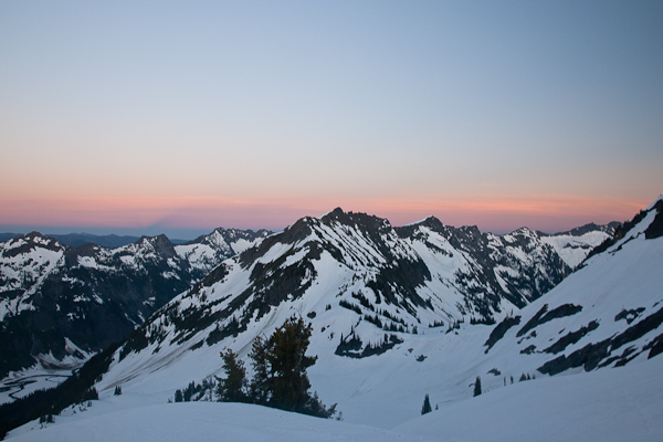
Beautiful sunset greeted us after our climbing day
A leisurely morning in camp was enjoyed the next day as we ate a hot meal, slowly packed our items up and began our descent back down.

Good morning! A leisurely morning in camp is a great thing

After gaining Boulder Pass once again we descended into shady snow, which required crampons, though the snow was still soft enough such that feet would slide a few inches before your points would dig in, making for trying conditions for travel. We managed to descend easily enough and before long were back on the trail above the stream crossing. This time we followed the trail much better, only straying in a few spots where snow covered the way, but easily finding the trail on the opposite side. The stream crossing was just as cold, but felt pretty nice as we were descending into the heat of a July day.

The last four miles along the river took a few days seemingly- Nicole and I discussing the merits of bringing inflatable kayaks along with for our next approach along a river. We rounded a few corners saw plenty of whitewater and both decided walking was just fine. The climb was strenuous, but was also a great introduction to glacier climbs- hopefully something we'll be doing a lot more in years to come!