|
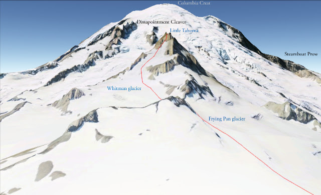
| DC Route up Mt. Rainier |
Much of our climbing this past year had been to prep for an attempt on Mt Rainier, so naturally we were excited to finally be attempting the mountain. I checked the weather carefully early in the week and wonderful calm conditions were predicted, so it came as a shock when we picked up Dave and Becky to hear these two hardcore climbers discuss the merits of attempting the climb given the weather forecast. WHA? I realized I had gotten lazy and forgot to check how the forecast had evolved over the last few days, and evolved it had! the UW ATMOS report for Rainier was calling for 60 mph winds at the summit and a high around 20. Still, the weather didn't call for any actual fronts to move in, just some wind....
We discussed for a while and ended up deciding to do the Tatoosh Traverse, a low level (compared to Rainier) traverse that bags anywhere from 7-10 peaks along a 2 day fun scrambling route. If WA has taught us any lessons, however, it is to pack for all adventures, so we left town with double plastic boots, hiking boots for a scramble trip, skis and ski boots and lots of food.
We drove down towards the mountain, quietly disappointed that our plans were being shifted, but putting a positive spin on a weekend out in the mountains. Mental reinforcements came in the form of a text message from another friend who had summited Rainier: "Forecast doesn't look that bad, go for it!" It was all the encouragement we needed to switch back to plan A.
After all the alternate trip planning in town before leaving and the long drive down, we only left the parking lot at around 11AM - fine for a day trip to Muir, but a bit late if you want to eat, drink and get to sleep early in the evening. About a mile up the trail I had a mental image burn into my mind's eye.... it was a key... no key chain, in the side of a green car. Panning out... that's a Subaru! and... it looks like our Subaru, but that can't be our key because that's in my pocket right here.... shaking the image from my head and frisking my pockets down more throughly than a TSA agent, I concluded that I had seen our key... and it was still down in the parking lot. To the amusement of the tourists nearby, I schwacked into some trees nearby and hid my backpack and ran down the trail, in ski boots. Some folks flagged me down to ask if everything was OK - kind of them, as running down a trail without a backpack is a somewhat odd activity. After the 4th time I joked about "fast and light" I just nodded and kept going. A few families making their way up the trail with kids hauling small A-frame skipacks was inspiring. They understood immediately and asked me what I had forgotten. "Sorry, don't have an extra one of those." was their response. I arrived back at the parking lot, and indeed the key was there. I snatched it up, closed the pocket, zipped it shut, made sure it was zipped shut, felt around for holes in the pocket, and then began the surpringly less exhausting run uphill. For the curious - try running downhill and then uphill in ski boots - uphill is way easier.
 |
| First views of Camp Muir and a very sharp point Anvil rock impression. |
I hauled up the trail and caught up with Nicole, Dave and Becky, who had slowed to an easy pace waiting for me to catch up. We had a quick lunch and continued our ascent to Camp Muir, which was rather uneventful. We set up our camp among the old flat spots in dirty snow and set out to make water and food quickly and get to sleep. Despite our best efforts and speedy work, we weren't in the tents shut-eye until 7pm. Nicole was battling with upset stomach and general high altitude woes of not being able to eat well and fatigue. She went to bed hoping to feel better in the morning. I slept for about 2 hours, and then watched the minutes roll by on my watch. The winds were certainly picking up, but a tent has a way of distorting the seriousness of a gale. Rising to go to the bathroom in the middle of the night, our tent was seemingly having difficulty staying upright, but upon standing up outside, the winds were steady, but not too strong. I love our tent choice - Black Diamond First Light, but I question why I can't guyline it down better, what's up with that?
The alarm went off and we raced outside to start getting ready. Nicole, who usually takes a few minutes to wake up in town, was up and outside and getting ready - I guess a few hours got her over her altitude symptoms! Becky, on the other hand, had not had the best of nights, and unfortunately decided not to join as we were roping up. Loosing another strong cog from our team wasn't ideal, but she was unlikely to feel any better while working hard and getting less oxygen up high. Nicole, Dave and I started up the traverse of the Cowlitz. As we scrambled onto Cathedral Rocks, the wind suddenly went from Nicole's sails (unfortuately the winds didn't die elsewhere). Her symptoms from the previous night had returned, and she didn't feel strong enough to head up and likely have them worsen. We headed back down to camp and she laid down in the tent and tried to salvage some sleep. Dave and I looked at the time and figured we still had a shot. With a very established route, we felt safe as a team of 2. There were hundreds of people ahead of us, so snow bridges would be tested, we would travel carefully, and as a backup, there were hunderds of people on the route that could lend a hand. The last consideration was certainly only a bonus, I don't feel it was a main reason for us to push as a team of two. On the Emmons, I likely would have opted to stay in camp, not wanting to put us into a more "remote" portion of the mountain with less than 3 on a rope. But we turned around and recilmbed up to Cathedral rocks, and on towards Ingram
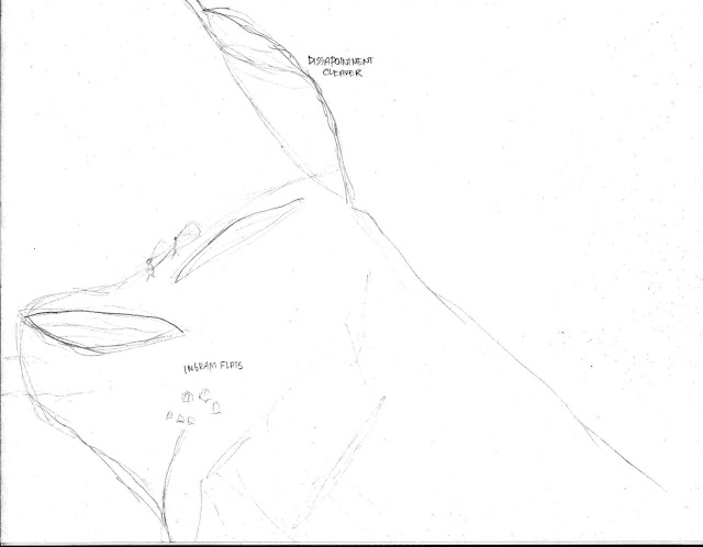 |
| Route beyond Ingram Flats with massively oversized climbers approaching the Cleaver |
Because we were behind our scheduled departure we felt a need to hurry along. I didn't stop to think of the large number of guided groups that were moving slowly below us. If they had their timing logistics worked out, which they do, we didn't have to worry. But we pushed on quickly, and in under two hours were above the cleaver and pushing uphill on the snow slopes beyond. The route was in magnificent shape - a walkway of snow. On the less steep areas we cut a switchback to pass slower parties and were happy with our progress and speed up the mountain. At times I was amazed at the spectacles around us. Large seracs lay around on top of the old snow. Gaping crevasses could be seen not far from the bootpack. One particular crevasse had amazing icicles hanging down and pointing down into the depths. The path gave that crevasse a wide berth before climbing above it.
 |
| Crevasse along the DC route |
Then the winds started. All of a sudden ice pellets were being flung towards us at high velocity. Wind gusts would make us stop every few steps and brace ourselves against the wind. A few false summits passed and we were looking up a few hundred feet or so at what we figured was the crater rim. It was very close, which was only possible to guess at because the climbers ahead of us up there were normal sized instead of ant-like. Despite a few half hearted steps uphill, I knew that the cold I felt creeping deeply into my hands and chest meant I should turn around.
 |
| Near our turn-around |
We had already discussed the possibility of turning around, so when I motioned to Dave that we needed to flip-it, he knew what I meant right away and we headed down. I only fully realized how cold I was on the descent. Still blown by the same wind, but not working the body so hard to produce as much heat, I began to shake. We finally stopped in a sheltered spot where Dave switched gloves with me and I got my down jacket put on... finally started to feel warmer, but it took a long time for feeling to return to my arms. Several guides reminded us and another party seeking shelter with us, that the feature we were in was a large snow plug on top of a crevasse. Yeah dude, we know! It's an excellent wind block! We took off quickly after I had warmed enough to make self arrest possible and scurried down the last few switchbacks to the top of the cleaver where we took another break on some rocks to eat and rest some more before the trudge down the cleaver.
The rest of the descent went well and we moved fast again. We de-cramponed and de-roped for the last scramble across Cathedral rocks and just walked carefully across the Cowlitz back to camp. I promptly passed out for a 3 hour nap. We generally lounged in camp and eventually packed up to head down. Having brought the skis up, I took off down the snowfield and skiied fairly quickly down to Pebble Creek where I started the confusing walk down the trails to Paradise. I'm fairly certain I took the longest way back... not being familiar with how these "trails" (they're more like sidewalks) actually run, I think I took a tour of the upper meadows around Paradise before dropping down to the parking lot. Thankfully Nicole took the wheel on the way home while I alternated making small talk about other climbs with snoring.